
Trip Summary: In this trip we did three relatively short backpacks, a two day hike through the
Regional Map

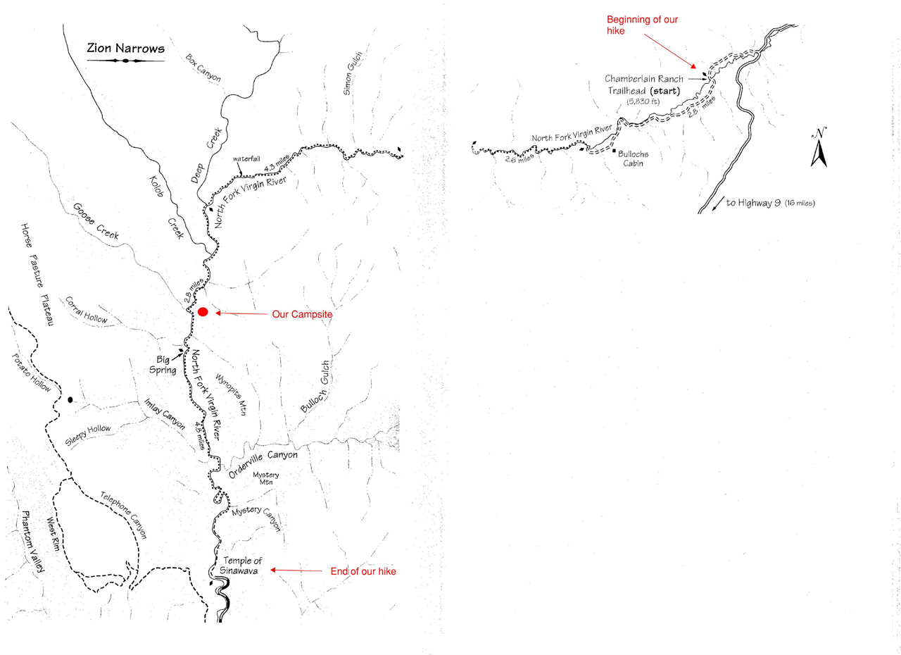
The Virgin River Narrows
(September 20th & 21st)
Summary: We all met up at the big campground at Zion on the afternoon of Sunday, September 19th. I had flown into Las Vegas that morning & then drove to the park. We stayed at the campground that first night. The next morning we were shuttled to the point where we began our two day (17.3 mile) hike through the Virgin River narrows. The first several miles of this hike are on private property, the Chamberlain Ranch. While this was not a particularly long hike, what made it strenuous was the fact that most of the time you were walking in the river itself. This did not pose anything really difficult until we passed the Virgin River/Deep Creek confluence. The water from deep creek doubles the flow of the Virgin River. Moreover, it is at this point that the character of the river bottom changes significantly. From the Deep Creek Confluence to the end of the hike a lot of the route was on big, slick boulders submerged in knee deep water. I read somewhere that it would be like walking through bowling balls under the water. The progress was slow for most of the time – just plant foot, slip, catch yourself, try not to fall into the water, plant the next foot, slip, regain balance & repeat for the next 10 miles. The time in which we were there the river was at a low level. There were some deep areas, but those sections were avoidable. The deepest sections we had to go through that could not be avoided were about waist deep – making dry bags essential if you want to hike these narrows. For most of the year, portions of this hike actually require some swimming. The narrows are also frequently off limits to hikers due to high water or flash flood threats. During the last three or so miles the canyon became chocked full of “day-hikers”, coming up from the other end to experience a little bit of the narrows. I went from having what seemed like the whole canyon to myself to feeling like I was in a crowded elevator. Before this point we had only encountered two other people during our time in the Narrows (and none during the first day). After exiting the narrows and walking back to the road we took the free shuttle back to the main campground at Zion NP. That evening Paul, Skipper and I went into Springdale, bought a few groceries, bottles of wine and beer, and I cooked dinner that night for the group using the stove in Bill’s camper. The next morning we headed to the northwest side of the Park for our Kolob Canyons hike.
- Map of Virgin River Narrows -
PICTURED BELOW: Within the first few miles of the Virgin River narrows - this is still on the Chamberlain Ranch property (private property) (day 1)

PICTURED BELOW: Within the first few miles of the Virgin River narrows - this is still on the Chamberlain Ranch property (day 1)

PICTURED BELOW: Some of my group - within the first few miles of the Virgin River narrows - this is still on the Chamberlain Ranch property (day 1)

PICTURED BELOW: Virgin river narrows - Zion National Park (day 1)

PICTURED BELOW: James above a waterfall - Virgin river narrows - Zion National Park (day 1)

PICTURED BELOW: About to enter a very tight section - Virgin river narrows - Zion National Park (day 1)

PICTURED BELOW: Virgin river narrows - Zion National Park (day 1)

PICTURED BELOW: preparing to enter another tight section of the canyon - Virgin river narrows - Zion National Park (day 1)

PICTURED BELOW: Virgin river narrows - Zion National Park (day 1)

PICTURED BELOW: Virgin river narrows - just above that night's camp - Zion National Park (day 2)

PICTURED BELOW: Virgin river narrows - Zion National Park (day 2)

PICTURED BELOW: Virgin river narrows - Zion National Park (day 2)

PICTURED BELOW: Paul cooling off in The Big Spring - with Katie at right - Virgin river narrows - Zion National Park (day 2 of 2)

PICTURED BELOW: Virgin river narrows - Zion National Park (day 2) - This is a memorable section for me because it was an even bigger pain in the ass to get through (deep pools & big debris piles). I was out about a hundred yards in front of the rest of the group. Just before I turned around to take this picture I gestured to Bill to stay left. I made an emphatic pointing motion to stay left and work through a large log jam, rather than stay in the river. He gave the okay, but apparently as I turned around to continue to find the best way to proceed down-canyon, he continued through the river and was soon underwater - bobbing up & down in the drink. Someone else in the group fished him out. That was really the only time during the two day trip through the Zion narrows that one of us ventured into one of the deep pools & had to been scooped out of the river.

PICTURED BELOW: Virgin river narrows - Zion National Park (day 2)

Kolob Canyons
(September 22nd, 23rd & 24th)
Summary: This portion of the trip was very leisurely, easy hiking. If you want to avoid crowds at Zion this is the place to go. That was a big part of the reason we went to the Kolob Canyons. We encountered only two other backpackers in the canyon we hiked & camped (the canyon containing La Verkin Creek). The hike in was about 7 miles to our campsite, which was near Kolob Arch. For day two we went to the Arch and further down La Verkin Creek to Bear Trap Canyon, which had a great waterfall. Day three was the quick seven mile hike out so we could hit the road and head towards Buckskin Gulch. If you go there is a really great spring near the mouth of Hop Valley that I drew all of our water from (for the three days in the Kolob Canyons). It was about 1/3 mile from our campsite and has very good flow. It is marked on some topo maps and can be found on the south side of the creek between two cottonwood trees (near the mouth of Hop Valley). The water from the creek itself is just fine (after filter), but nothing beats fresh cold spring water – and skipping the chore of pumping the filter.
- Map of Kolob Canyons -

PICTURED BELOW: Canyon face of one of the "finger canyons" - Kolob Canyons Area, Zion National Park (day 1 of 3 in Kolob Canyon section)

PICTURED BELOW: Me - at a break during the first day's hike through the Kolob Canyons section of Zion NP (day 1 of 3 in Kolob Canyons Area)

PICTURED BELOW: La Verkin Creek at a great natural swimming pool - Kolob Canyons Area, Zion National Park (day 1 of 3 in Kolob Canyon section)

PICTURED BELOW: La Verkin Creek and Gregory Butte - Kolob Canyons Area, Zion National Park (day 1 of 3 in Kolob Canyon section)

PICTURED BELOW: Me taking a break at La Verkin Creek - Kolob Canyons Area, Zion National Park (day 1 of 3 in Kolob Canyon section)

PICTURED BELOW: Me using La Verkin Creek to cool off in the ninety degree temperatures - Kolob Canyons Area, Zion National Park (day 3 of 3 in Kolob Canyon section)

PICTURED BELOW: La Verkin Creek - Kolob Canyons Area, Zion National Park (day 1 of 3 in Kolob Canyon section)

PICTURED BELOW: Kolob Arch - Kolob Canyons Area, Zion National Park (day 2 of 3 in Kolob Canyon section) - The span of this arch, at its base, is about 300 feet.

PICTURED BELOW: La Verkin Creek - Kolob Canyons Area, Zion National Park (day 2 of 3 in Kolob Canyon section)

PICTURED BELOW: waterfall within Bear Trap Canyon - Kolob Canyons Area, Zion National Park (day 2 of 3 in Kolob Canyon section)

PICTURED BELOW: family of female turkeys passing near our camp in the Kolob Canyons - evening of day 2 in the Kolob Canyons area

PICTURED BELOW: This picture was taken near our campsite - Kolob Canyons Area, Zion National Park (day 3 of 3 in Kolob Canyon section)

Buckskin Gulch & Upper Paria Canyon
(September 25th & 26th)
Summary: After wrapping up our time at Zion NP, we headed to the Paria/Vermilion Cliffs Wilderness area between Kanab Utah & Page Arizona. On the way we stopped in Kanab so I could buy a few groceries and we could all take showers (showers are available within two RV parks in Kanab – for a small fee). After making a quick stop at the BLM office in Kanab, we headed to the “Stateline” campsite near Buckskin Gulch. This is a primitive site with no water, just a few picnic tables, flat spots to throw up tents and a pit toilet. It is free to camp there, though. BLM camping rules are pretty lax. We could have thrown tents up anywhere. That night I cooked dinner for the group, again using the stove in Bill’s camper, and we sorted out gear for the next two days in Buckskin Gulch and the Paria Canyon. I did Paria Canyon in 2008 as a 6 day backpack from White House TH to Lees Ferry (where the Paria River empties into the Colorado River). After doing that trip I decided to go back one day to do Buckskin Gulch, which feeds into the Paria River. Due to irrigation use of Paria River water during the fall further upstream near Cannonville, Utah & Tropic, Utah, the Paria Canyon is completely dry this time of year. When I did the Paria Canyon hike in 2008 it was in April and the Paria was flowing throughout the canyon. A flowing Paria River makes hiking in the canyon much more scenic. We entered Buckskin Gulch using Wire Pass. Buckskin Gulch was a 13.5 mile hike with only a few minor obstacles. The only one that required a rope was within the last mile & a half. While Buckskin is also known for having pools of cold stagnant water, it was completely dry when we were there. After getting through Buckskin we camped near the Buckskin Gulch/Paria River confluence. The next day was a short 7 mile hike out to the White House TH of the Paria Canyon. The only "wet" section in the Paria Canyon during this trip was near its confluence with Buckskin. At that point there where unavoidable areas of deep mud and large sections of deep quicksand.
- Map of Paria Canyon/Vermilion Cliffs Wilderness -

- Map of Buckskin Gulch/Upper Paria Canyon -

PICTURED BELOW: This picture doesn't really belong with this trip. This picture was taken above the Stateline Campground. You can even see the green roof of the pit toilet. This was a pic taken during my 2008 trip to the Paria/Vermilion Cliffs Wilderness. This picture was not taken by me, but rather was sent to me from a couple that was camping next to us - Neil & Diane Hedges from western Washington state. In 2008 we camped two frigid nights at Stateline after our six day backpack through the Paria Canyon, before flying home. We shared one of our dinners with the Hedges one night and they shared a few cold beers from their camper the next night during our time at the Stateline camp in 2008. Neil emailed this to me when I got home. Since it was dark when we arrived at Stateline for this trip and we started out very early down Buckskin the next morning, I could not take any photos of the Stateline camp, so I'm inserting this one. It shows the Stateline camp below, which is directly on the Utah/Arizona state line, and the "cockscomb" in the background.

PICTURED BELOW: We entered Buckskin Gulch via Wire Pass. This is a picture of the first mile or so of wire pass, which as you can see begins as a broad desert wash.

PICTURED BELOW: This is the first point in which Wire Pass slots up from the wash that feeds into it - (day 1 of 2 of Buckskin Gulch/Upper Paria Canyon - Paria/Vermilion Cliffs Wilderness Area - Utah)

PICTURED BELOW: Large Alcove at the intersection of Wire Pass & Buckskin Gulch - (day 1 of 2 of Buckskin Gulch/Upper Paria Canyon - Paria/Vermilion Cliffs Wilderness Area - Utah)

PICTURED BELOW: Petroglyph - (Pre-Colombian), at the intersection of Buckskin Gulch & Wire Pass (day 1 of 2 of Buckskin Gulch/Upper Paria Canyon - Paria/Vermilion Cliffs Wilderness Area - Utah). They have not found ruins of any permanent prehistoric structures or Pueblos in this immediate area, so this was likely just a travel route for these groups. The closest large Pueblos inhabited by the Ancestral Puebloans would have been in the Cedar Mesa area in SE Utah & the Kayenta area in NE Arizona.

PICTURED BELOW: Petroglyph- (Pre-Colombian), at the intersection of Buckskin Gulch & Wire Pass (day 1 of 2 of Buckskin Gulch/Upper Paria Canyon

PICTURED BELOW: Me pointing towards some small petroglyphs - a snake (below) and either a big horn sheep, pronghorn antelope or deer (above) - at the intersection of Buckskin Gulch & Wire Pass (day 1 of 2 of Buckskin Gulch/Upper Paria Canyon

PICTURED BELOW: Buckskin Gulch - (day 1 of 2 of Buckskin Gulch/Upper Paria Canyon - Paria/Vermilion Cliffs Wilderness Area - Utah)

PICTURED BELOW: Buckskin Gulch - (day 1 of 2 of Buckskin Gulch/Upper Paria Canyon - Paria/Vermilion Cliffs Wilderness Area - Utah)

PICTURED BELOW: Buckskin Gulch - (day 1 of 2 of Buckskin Gulch/Upper Paria Canyon - Paria/Vermilion Cliffs Wilderness Area - Utah)

PICTURED BELOW: Buckskin Gulch - (day 1 of 2 of Buckskin Gulch/Upper Paria Canyon - Paria/Vermilion Cliffs Wilderness Area - Utah)

PICTURED BELOW: Large Alcove in Buckskin Gulch - (day 1 of 2 of Buckskin Gulch/Upper Paria Canyon - Paria/Vermilion Cliffs Wilderness Area - Utah)

PICTURED BELOW: Big Alcove high up in Buckskin Gulch - (day 1 of 2 of Buckskin Gulch/Upper Paria Canyon - Paria/Vermilion Cliffs Wilderness Area - Utah)

PICTURED BELOW: Buckskin Gulch - (day 1 of 2 of Buckskin Gulch/Upper Paria Canyon - Paria/Vermilion Cliffs Wilderness Area - Utah)

PICTURED BELOW: Buckskin Gulch - (day 1 of 2 of Buckskin Gulch/Upper Paria Canyon - Paria/Vermilion Cliffs Wilderness Area - Utah)

PICTURED BELOW: Log jammed high in Buckskin Gulch during a recent flash flood - (day 1 of 2 of Buckskin Gulch/Upper Paria Canyon - Paria/Vermilion Cliffs Wilderness Area - Utah)

PICTURED BELOW: Buckskin Gulch - (day 1 of 2 of Buckskin Gulch/Upper Paria Canyon - Paria/Vermilion Cliffs Wilderness Area - Utah)

PICTURED BELOW: Buckskin Gulch - (day 1 of 2 of Buckskin Gulch/Upper Paria Canyon - Paria/Vermilion Cliffs Wilderness Area - Utah)

PICTURED BELOW: Buckskin Gulch - (day 1 of 2 of Buckskin Gulch/Upper Paria Canyon - Paria/Vermilion Cliffs Wilderness Area - Utah)

PICTURED BELOW: Buckskin Gulch - (day 1 of 2 of Buckskin Gulch/Upper Paria Canyon - Paria/Vermilion Cliffs Wilderness Area - Utah)

PICTURED BELOW: Buckskin Gulch - (day 1 of 2 of Buckskin Gulch/Upper Paria Canyon - Paria/Vermilion Cliffs Wilderness Area - Utah)

PICTURED BELOW: Buckskin Gulch - (day 1 of 2 of Buckskin Gulch/Upper Paria Canyon - Paria/Vermilion Cliffs Wilderness Area - Utah)

PICTURED BELOW: Buckskin Gulch - (day 1 of 2 of Buckskin Gulch/Upper Paria Canyon - Paria/Vermilion Cliffs Wilderness Area - Utah)

PICTURED BELOW: Buckskin Gulch - (day 1 of 2 of Buckskin Gulch/Upper Paria Canyon - Paria/Vermilion Cliffs Wilderness Area - Utah)

PICTURED BELOW: Me using my coffee mug to gather some very heinous water seeping out in the last mile or mile & a half of Buckskin Gulch (near our campsite). Skipper & I had made the decision the night before that our group would not carry all the water necessary for our two days in Buckskin Gulch/Upper Paria Canyon. Based on our thinking, the two of us were confident that we would likely find some water near this location. So finding a small stream of this water in the sand (which tasted very bad) was in fact a big relief to me.

PICTURED BELOW: Our campsite on the top of a hill in a wide portion of Buckskin Gulch - near the Buckskin/Paria Canyon confluence. I also camped at this spot in 2008 during my six day hike through the entire Paria Canyon (all the way to the point where the Paria empties into the Colorado River).

PICTURED BELOW: Flower at our campsite in Buckskin Gulch

PICTURED BELOW: view from our Buckskin Gulch campsite

PICTURED BELOW: view from our Buckskin Gulch campsite

PICTURED BELOW: near the Buckskin Gulch/Paria Canyon intersection (day 2 of 2 of Buckskin Gulch/Upper Paria Canyon - Paria/Vermilion Cliffs Wilderness Area - Utah)

PICTURED BELOW: Upper Paria Canyon (day 2 of 2 of Buckskin Gulch/Upper Paria Canyon - Paria/Vermilion Cliffs Wilderness Area - Utah)

PICTURED BELOW: Slide Arch - Upper Paria Canyon (day 2 of 2 of Buckskin Gulch/Upper Paria Canyon - Paria/Vermilion Cliffs Wilderness Area - Utah)

PICTURED BELOW: Upper Paria Canyon (day 2 of 2 of Buckskin Gulch/Upper Paria Canyon - Paria/Vermilion Cliffs Wilderness Area - Utah)

PICTURED BELOW: Upper Paria Canyon (day 2 of 2 of Buckskin Gulch/Upper Paria Canyon - Paria/Vermilion Cliffs Wilderness Area - Utah)

PICTURED BELOW: Upper Paria Canyon - above the point where the canyon "narrows" begin. Here you can see the petrified sand dunes that surround the broad wash of Paria Canyon. These sand dunes were formed during the Jurassic period, and are now petrified - (day 2 of 2 of Buckskin Gulch/Upper Paria Canyon - Paria/Vermilion Cliffs Wilderness Area - Utah)

PICTURED BELOW: Upper Paria Canyon - (day 2 of 2 of Buckskin Gulch/Upper Paria Canyon - Paria/Vermilion Cliffs Wilderness Area - Utah)

PICTURED BELOW: We spent the afternoon on the Las Vegas Strip before the flight home. We were on the last Las Vegas to Austin direct flight of the day offered by Southwest (leaving at 7 pm)
