
East and West Wallowa River Loop Combination -- Eagle Cap Wilderness -- Oregon -- September 2018
Location within Oregon

Trip Summary:
For a late summer/early fall trip I had been kicking around the idea of heading out to Hell’s Canyon, which follows the Snake River on the Idaho/Oregon border. It’s well known for its solitude, remoteness, and Grand Canyon like grandeur. In researching and plotting a potential 60-mile hike in Hells Canyon, I became concerned about complicated logistics, the costs of local shuttle services needed to complete such a route and that late summer/early fall might not be the best time to visit Hells Canyon. While studying road and topo maps of Hells Canyon, I had noticed that just to the west in Oregon was an area called the Wallowa Mountains, which were dotted with alpine lakes and a network of forest service trails in an area called the Eagle Cap Wilderness.
After a little research into the Eagle Cap I learned two major points – it’s a great place to hike, fish and backpack, with scenery in an “Alpine Lakes Basin” reminiscent of the Sierra Nevada, but not to expect a high level of solitude in the backcountry there. I really value solitude in the back country, so the idea of encountering national park like numbers of other people on a backpacking trip gave me something to think about. But after looking at an outdoor travel article from CNN.com of all places that the Eagle Cap Wilderness is a life-list, top ten, wilderness destination in the U.S., I got excited about the idea of going there, despite its popularity. Another plus is that the elevations in the Eagle Cap Wilderness are mostly less than 9,000 feet, meaning that I would not need much altitude acclimation.
James Bruce accompanied me on this trip. I reached out to a few other people, but honestly didn’t go to a lot of effort to find more people to join us. It was planned without much advance notice. We flew into Portland on Sunday, September 9th, arriving around 3 pm. The drive from Portland to the Eagle Cap Wilderness takes about 5 to 6 hours. You’re essentially crossing the entire state of Oregon following the Columbia River, which is the border between Oregon and Washington. It was a very scenic drive. We stayed the night in La Grande, Oregon, which is about an hour to an hour and a half’s drive from the Eagle Cap. The next morning, we drove through some of the prettiest farm land I’ve ever seen before arriving in the small touristy town of Joseph, Oregon, which is located at the foot of the massive Wallowa Lake and the Wallowa Mountains. After breakfast at one of several little restaurants in Joseph we headed to the parking area just past the head of Wallowa Lake, which is also the trailhead access point to the East and West Wallowa River trails.
The route we did took 5 full days and was about 43 miles long - encompassing what are called the East Wallowa and West Wallowa River loops. I wish my work schedule would have allowed 6 or 7 days out there, but being self-employed, it's hard to take more than a week away because you're not getting paid! There are so many places to explore and peaks you can summit if you have spare days. We camped two nights at Aneroid Lake, one night at Frazier Lake and one night at Douglas Lake. We spent our “off day” between the two nights at Aneroid Lake going to Dollar Lake and route-finding our way over to and up Pete’s Point, which is a prominent peak near Aneroid Lake. I would have liked to have had more days to try and summit Eagle Cap Peak and explore some of the other incredibly scenic Alpine Lakes out there.
Weather was a mixed bag, but it was generally pretty cold when we were out there. During the first few days (as you can see in the pics below) it was overcast - with our camp at Aneroid Lake being essentially at cloud level. Afternoon highs were in the low 50s to mid-40s. Every night the temps dropped to at or below freezing. During the last morning at Douglas Lake, our water bags froze. Each night I slept with the fuel canister for the stove inside my sleeping bag (at my feet) to keep it from freezing. I was using iso-butane fuel. Those don’t work too well if they get too cold. During our night & morning at Frazier Lake we got a decent sleet/ice thunder storm. But at least we did not have any precipitation while we were hiking.
The lack of solitude I was warned about in the “alpine lakes basin” of the Eagle Cap Wilderness proved to be generally true. I can’t imagine what the numbers of backpackers & anglers must be out there before Labor Day, but I felt like I could have used more solitude at Frazier Lake, the lake we camped at during the third night. There were several other groups there, spread out on the north shore of the lake within the stands of pine trees. Because of its location within the Alpine Lakes Basin, Frazier Lake is a heavily used stopping off point in the wilderness, so it wasn’t that surprising that there were several other small groups camping there with us. We usually encountered at least a few other people during the day on our hikes from point to point along the route. We also passed several groups on horse back when we were close to the trailhead at Wallowa Lake. Other than lots of squirrels and chipmunks, ducks on the lakes, and hearing a few pikas in the rocky areas up high, we did not encounter much wildlife out there.
Map of our Route & Side Trips (in red), about 43 miles

PICTURED BELOW: A mile or two in, gaining elevation, with a decent view of Wallowa Lake. Day one had a big elevation gain of 3,000 feet up to Aneroid Lake, but was short as far as distance at only about 6 miles.

PICTURED BELOW: Me at the Eagle Cap Wilderness Boundary within the Wallowa-Whitman National Forest

PICTURED BELOW: View of the lake from our camp at Aneroid Lake. We camped two nights here

PICTURED BELOW: Our camp (two tents) at Aneroid Lake. My tent is on the left. James's tent is on the right. They are both Nemo ultra-light brand tents. The "pack weight" of my tent is just under 2 pounds.

PICTURED BELOW: Me having dinner, after I cooked it, at our Aneroid Lake camp kitchen

PICTURED BELOW: The dinner I made for night one at Aneroid Lake - shrimp with rice, coconut, pineapple & bell pepper. At home, I used my food dehydrator to dehydrate the cooked shrimp and red & yellow bell pepper, and used the dried diced pineapple, shaved coconut & instant rice off the shelf from the grocery store. All re-hydrated very well and made for a very good, but very lightweight & easy, quick one pot meal.

PICTURED BELOW: Hanging food and other smell-able items at the Aneroid Lake camp - out of the reach of squirrels, chipmunks and any curious & hungry bears

PICTURED BELOW: View from our camp at Aneroid Lake. The peak in the center left is Pete's Point. We made a side trip on day two over to Dollar Lake and then made a scramble up Pete's Point.

PICTURED BELOW: Dollar Lake on day two. I was going to top off my water bottle here, but as I got to the bank of this lake I noticed it was littered with elk tracks and the water smelled like a dead animal. So I just decided to ration my water the rest of the day rather than drink that smelly stuff.

PICTURED BELOW: Dollar Lake and Aneroid Mountain

PICTURED BELOW: View down the valley of the East Wallow River, between Dollar Lake and Tenderfoot Pass on the way to Pete's Point

PICTURED BELOW: James and I climbing our way down a very steep slope of rocks on our way to Pete's Point on day two

PICTURED BELOW: View from Pete's Point of Jewett Lake (front) and Aneroid Lake (back) down the valley of the East Wallowa River. Our camp for that night and the previous night was at Aneroid Lake.

PICTURED BELOW: Me during the scramble up Pete's Point

PICTURED BELOW: View from Pete's Point of Tenderfoot Pass (lower left corner) and the North Imnaha River valley

PICTURED BELOW: Me refilling my water bottle back at our camp at Aneroid Lake after the hike to Dollar Lake and scramble up Pete's Point on day two. I used one of those "life straws" that screwed into my water bottle. It filters out any of those bad organisms in the water that can make you sick.

PICTURED BELOW: Aneroid Lake in the evening (at our camp)

PICTURED BELOW: Breakfast I made for the morning we broke camp at Aneroid Lake -- rice with cherries, blueberries and a little brown sugar.

PICTURED BELOW: James on the hike between Tenderfoot Pass & Polaris Pass - day three

PICTURED BELOW: On the way up to Polaris Pass, looking down the valley of the North Fork of the Imnaha River

PICTURED BELOW: Me at Polaris Pass -- looking to the peaks on the west side of the West Wallowa River valley

PICTURED BELOW: At Polaris Pass, looking down the valley of the West Wallowa River. The path took a nose-dive just beyond this point - dropping 2,000 feet over about 3/4 mile distance. The upper part of the descent here had a very steep angle and the path was loose rock scree. A stumble could send you sliding/falling down hundreds of feet so you had to watch your step a little. But the views were amazing!

PICTURED BELOW: Near the end of the descent from Polaris Pass - West Wallowa River valley. You can see the trail gets flatter and is well worn in the lower left of the photo.

PICTURED BELOW: Some bright white peaks within a mile of Frazier Lake - our camp for night three

PICTURED BELOW: Our camp at Frazier Lake (night 3) - my tent is on the right

PICTURED BELOW: Leaving Frazier Lake after enduring an overnight and morning ice/sleet storm.

PICTURED BELOW: On day four - between Frazier Lake and Glacier Lake with a good view of Cusick Mountain

PICTURED BELOW: On day four - very close to Glacier Lake - looking down on the West Fork of the Wallowa River

PICTURED BELOW: First view of Glacier Lake - you can see a little of the ice/sleet on the ground from the early morning's storm (a rare combo of thunder, lightning & ice/sleet)

PICTURED BELOW: Glacier Lake and Eagle Cap Peak

PICTURED BELOW: Glacier Lake and Eagle Cap Peak

PICTURED BELOW: Glacier Lake and Eagle Cap Peak

PICTURED BELOW: View from near Glacier Pass of Glacier Lake, the West Wallowa River, Cusick Mountain and the area around Hawkins Pass

PICTURED BELOW: Me refilling my water bottle in a stream between Glacier Pass and Moccasin Lake

PICTURED BELOW: Moccasin Lake and Eagle Cap Peak - on day four of our hike

PICTURED BELOW: Douglas Lake - at our campsite

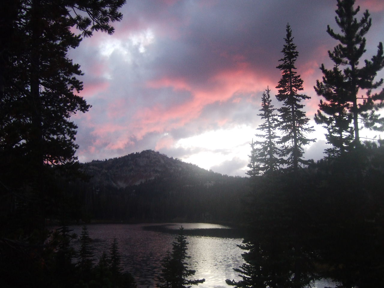
PICTURED BELOW: Sunset from our Douglas Lake campsite right before the fourth and final night in the Eagle Cap Wilderness.
PICTURED BELOW: Frosty morning at our Douglas Lake campsite on day five. My tent is on the right. Also pictured is my "Platypus Basecamp" water filter (dirty water bag hanging & clean water bag on the ground). We used this to filter water from the lakes at camp.

PICTURED BELOW: Camp kitchen at Douglas Lake

PICTURED BELOW: Another picture of Douglas Lake from our campsite.

PICTURED BELOW: On the long hike out, back to the car, on day five - This is Horseshoe Lake, the last lake we passed in the "Alpine Lakes Basin" of the Eagle Cap Wilderness

PICTURED BELOW: "Six Mile Meadow" in the West Wallowa River valley

PICTURED BELOW: Back at the parking area near the head of Wallowa Lake, where we left the car. This is just outside Wallowa River State Park and the town of Joseph, Oregon. This was also the beginning & end point of our five day journey in the Eagle Cap Wilderness. I wish it could have been longer.
