Trip Summary: James, Skipper, Bill W. & I flew into Billings, Montana, arriving on the morning of August 9th. We then drove the approx. six hour drive to the east side of Glacier National Park. The four of us met up with Bill Allen at the KOA at St. Mary Lake near the St. Mary entrance to Glacier National Park, on the east central side of the Park (the other east side entrance points being at Two Medicine, Cut Bank, Many Glacier and Chief Mountain). We stayed at the KOA for two nights with three of us in one of the KOA cabins (about the size of a kid's fort in the back yard - essentially just a small shelter with a couple bunk beds) and two in Bill Allen's camper. The plan for the backcountry was a six day/five night hike covering the Ptarmigan Tunnel Area, Upper Belly River area, Mokowanis Valley, Stoney Indian Pass Area, and Upper Waterton Valley Area. This was essentially the same trip we had planned for October 2008, but had to modify our plans in '08 because of the closures of the Waterton Lake ferry service, certain park services, roads and border customs that close during the fall. The only areas we covered in '09 that we also hiked in Oct. 2008 were the Mokowanis valley area, Mokowanis Lake and the falls above Mokowanis Lake. The day after we arrived at the St. Mary KOA, Skipper & Bill Allen set up the shuttle for this trip, since we were starting the hike near the St. Mary Lodge and ending it at Goat Haunt, a very isolated ranger station at the edge of Waterton Lake. The only ways back to a road from Goat Haunt are a few days walk through the mountains or a 45 minute boat ride across Waterton Lake into Waterton, Canada. So Bill & Skipper set up a shuttle by leaving a car in Waterton so we would have a way to get back after we got off the boat in Waterton. While Skipper & Bill A. were driving back and forth from Waterton to leave the rental van at the Waterton marina, James & I did a "day hike" from the Many Glacier lodge area to Grinnell Glacier. The first several photos on this page are of that "day hike" (about 11 miles round trip). The next day, after our second night at the St. Mary KOA we drove to Many Glacier to begin the backcountry hike. After the ferry ride to Waterton, with about 50 or so clean looking tourists riding the ferry as a site seeing excursion between Waterton, Canada & Glacier N.P., we had dinner in Waterton and then made the drive back to the east side of Glacier N.P., staying at a hotel in East Glacier. We then drove back towards Billings. After an overnight at a Billings hotel, we flew home.
Day One - From Many Glacier Lodge area (closer to Swiftcurrent Motor Inn) up through the Ptarmigan Tunnel then to the head of Elizabeth Lake for night one
Day Two - From Elizabeth Lake head to Glenns Lake head for night two
Day Three - our "down day" - a day hike, without packs, to Mokowanis Lake, then off trail to Mokowanis Falls and up the flank of the falls to cirque containing Elizabeth Lake & Ipasha Lake, then headed back to Glenns Lake head for night three
Day Four - From Glenns Lake head to Stoney Indian Lake for night four
Day Five - From Stoney Indian Lake to Goat Haunt (we had planned a fifth night spent at Kootenai Lake, but decided to push all the way to Goat Haunt because we were tired of the bad weather and could catch the last ferry ride of the day out of Goat Haunt)
The weather: We had great weather for the day hike James & I did to Grinnell Glacier and for the first day of the backcountry hike. After that it rained every day, most of the day. There was some hope during the third morning when we were breaking camp at Glenns Lake. The low clouds covering the mountains started to push out and the sun came out for the first time in two days. But then steady bands of rain started around lunch time on the way up to Stoney Indian Pass and it continued raining off and on until we reached Goat Haunt the next afternoon. The coldest it got was during the last morning, at Stoney Indian Lake, when the temp. that morning dropped to 39 degrees F. (reading off my thermometer when I woke up) and the rain didn't help make that feel any warmer. But that lower temperature was partly because Stoney Indian Lake was also our highest elevation campsite. When we reached Goat Haunt I asked the Customs guy there what the weather forecast was for that night. He just said "wet". After we got off the boat in Waterton and found a place to get a drink and eat dinner it started raining hard again and it was cold. I don't regret our decision to skip the final night at Kootenei Lake.
Map of Route -- Shown in Red
PICTURED BELOW: Many Glacier Lodge & Swiftcurrent Lake
PICTURED BELOW: Grinnell Lake, Angel Wing Mountain & Grinnell Falls (far right)
PICTURED BELOW: James (at right) on the hike to Grinnell Glacier
PICTURED BELOW: Me & Grinnell Lake
PICTURED BELOW: Grinnell Falls
PICTURED BELOW: Front to Back: Grinnell Lake, Lake Josephine & Lake Sherburne
PICTURED BELOW: Upper Grinnell Lake
PICTURED BELOW: Upper Grinnell Lake, flanking Grinnell Glacier, which is out of the photo to the left
PICTURED BELOW: photo I took on the way back from Grinnell Glacier
PICTURED BELOW: Mount Wilbur
PICTURED BELOW: photo I took on the way to the Ptarmigan Tunnel & ultimately Elizabeth Lake for night one
PICTURED BELOW: photo I took on the way to the Ptarmigan Tunnel & ultimately Elizabeth Lake for night one
PICTURED BELOW: photo I took on the way to the Ptarmigan Tunnel & ultimately Elizabeth Lake for night one
PICTURED BELOW: photo I took on the way to the Ptarmigan Tunnel & ultimately Elizabeth Lake for night one
PICTURED BELOW: Indian Paintbrush
PICTURED BELOW: photo I took on the way to the Ptarmigan Tunnel & ultimately Elizabeth Lake for night one
PICTURED BELOW: Me (left - green & gray pack) & James (right - yellow & red pack) on the nice well defined trail early on day one - on the way to the Ptarmigan Tunnel & ultimately Elizabeth Lake for night one - The "Ptarmigan Wall" is what is in front of us in this photo
PICTURED BELOW: There are an estimated 800 Black Bears & 350 Grizzly Bears in Glacier National Park
PICTURED BELOW: from left: Me, Bill Allen & Dr. James Bruce near Ptarmigan Falls (the falls are very tall, but fall into a narrow deep gorge, so while they looked really cool, I couldn't get a decent photo of the falls)
PICTURED BELOW: Bear Grass
PICTURED BELOW: looking back from the entrance of Ptarmigan Tunnel to Ptarmigan Lake & Mount Wilbur
PICTURED BELOW: from left: Bill Allen, Me & James Bruce taking a break at the entrance of the Ptarmigan Tunnel
PICTURED BELOW: Me, Ptarmigan Lake & Mount Wilbur in the background from near the entrance to Ptarmigan Tunnel
PICTURED BELOW: looking through the Ptarmigan Tunnel - the light is from the flash of the camera
PICTURED BELOW: Elizabeth Lake from the other end of the Ptarmigan Tunnel
PICTURED BELOW: Old Sun Glacier sitting on Mount Merritt - on the right is Natoas Peak
PICTURED BELOW: members of my group (at right) heading to Elizabeth Lake, in the distance to the upper left is Old Sun Glacier and Natoas Peak
PICTURED BELOW: Bill Allen & Elizabeth Lake
PICTURED BELOW: Elizabeth Lake
PICTURED BELOW: at the foot of Elizabeth Lake
PICTURED BELOW: heading to the head of Elizabeth Lake, our night one campsite
PICTURED BELOW: heading to the head of Elizabeth Lake, our night one campsite
PICTURED BELOW: Skipper; leaving Elizabeth Lake camp - heading to Glenns Lake for nights 2 & 3
PICTURED BELOW: Leaving Elizabeth Lake camp - heading to Glenns Lake
PICTURED BELOW: Me at Dawn Mist Falls (on the Belly River) between Elizabeth Lake and Cosley Lake
PICTURED BELOW: Below Dawn Mist Falls
PICTURED BELOW: Pine Marten (American Marten)
PICTURED BELOW: James fording the outlet of Cosley Lake on the way to Glenns Lake (we all had to do this crossing)
PICTURED BELOW: Picture I took on the way to Glenns Lake
PICTURED BELOW: Picture I took on the way to Glenns Lake
PICTURED BELOW: Picture I took on the way to Glenns Lake
PICTURED BELOW: front foot print of a small black bear near Glenns Lake (very distinguishable from grizzly tracks, which I saw some of last year)
PICTURED BELOW: Pyramid Peak in the clouds & the head of Glenns Lake
PICTURED BELOW: The tent I shared with James - at Glenns Lake camp (my home for nights 2 & 3)
PICTURED BELOW: Moose in Glenns Lake near our tents
PICTURED BELOW: Morning fog & the head of Glenns Lake; looking towards Cathedral Peak
PICTURED BELOW: Mokowanis Lake
PICTURED BELOW: heading up the side of the falls to Margaret Lake
PICTURED BELOW: Me entering the cloud covering Margaret Lake
PICTURED BELOW: Me heading back to Glenns Lake (below the falls)
PICTURED BELOW: Pyramid Peak, while the weather breifly cleared on morning three at the head of Glenns Lake
PICTURED BELOW: Portion of "Mokowanis Cascade" - below Atsina Lake (on the way to Stoney Indian Pass)
PICTURED BELOW: Atsina Lake, falls & Cathedral Peak (on the way to Stoney Indian Pass)
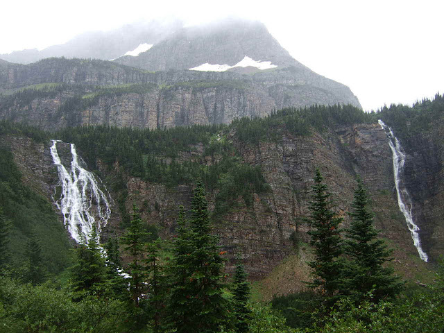
PICTURED BELOW: Paiota Falls (left), Atsina Falls (right) & Cathedral Peak (on the way to Stoney Indian Pass)
PICTURED BELOW: Atsina Lake (in foreground) & Glenns Lake (in the valley below)
PICTURED BELOW: Raven Quiver Falls (coming off Sue Lake); on the way to Stoney Indian Pass
PICTURED BELOW: just below Stoney Indian Pass
PICTURED BELOW: Pyramid Peak (at left) & an unnamed lake just below Stoney Indian Pass
PICTURED BELOW: Stoney Indian Pass & Wahcheechee Mountain
PICTURED BELOW: Me at a large cairn marking Stoney Indian Pass
PICTURED BELOW: looking down the other side of Stoney Indian Pass - at Stoney Indian Lake (pic. taken about 15 yards from the cairn in the picture above)
PICTURED BELOW: heading down to Stoney Indian Lake (camp for night 4)
PICTURED BELOW: Stoney Indian Lake
PICTURED BELOW: Skipper & James near Stoney Indian Lake
PICTURED BELOW: Walking around the north side of Stoney Indian Lake
PICTURED BELOW: cooking hash browns at Stony Indian Lake Camp
PICTURED BELOW: The tent I shared with James - at Stoney Indian Lake camp
PICTURED BELOW: Leaving Stoney Indian Lake
PICTURED BELOW: Thimbleberries (I was eating these on the trail). They are filet mignon for the bears.
PICTURED BELOW: Moose Track compared to my foot
PICTURED BELOW: Citadel Peaks in the Waterton Valley - a few miles from Goat Haunt & Waterton Lake
PICTURED BELOW: Me waiting at the dock at Goat Haunt
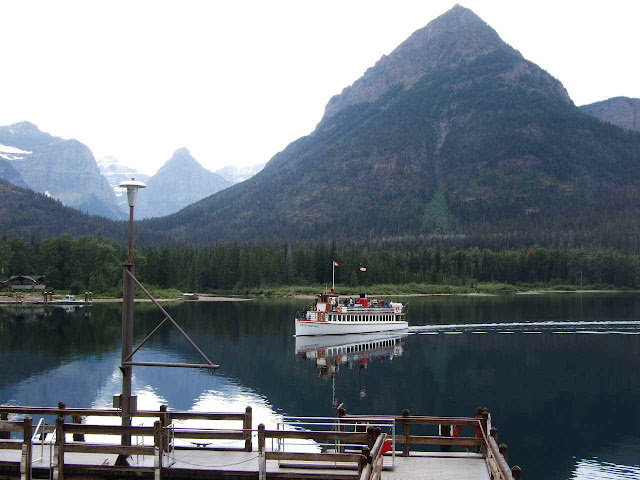
PICTURED BELOW: The ferry, called the "International", coming to the dock at Goat Haunt (our ride back to the real world); (info. on the ferry
PICTURED BELOW: Mt. Cleveland (the tallest peak in Glacier National Park); taken during the ferry ride
PICTURED BELOW: picture taken during the ferry ride across Waterton Lake
PICTURED BELOW: nearing Waterton townsite; the Prince of Wales Hotel is on the plateau at the foot of the lake
PICTURED BELOW: Prince of Wales Hotel in Waterton, Canada
PICTURED BELOW: Waterton Marina (Waterton, Canada)


