
A loop covering the Titcomb Basin, the Continental Divide Trail to Green River Pass and the Summit Lake Area to Elkhart Park -- September 2022

For this late summer trip, I finally visited one of my long-time
bucket list destinations, the Wind River Mountains in western Wyoming, more specifically,
the Bridger Wilderness, located within the Bridger-Teton National Forest. It’s
located south of Yellowstone and Grand Tetons national parks and unlike
national parks, the place we went is a designated wilderness, meaning that reservations,
permits, and strict guidelines are not an issue. The place is well known for
having incredible opportunities for day hiking, backpacking, rock climbing,
hunting and fishing. During our seven-day backpacking hike in the wilderness we
passed groups that were trout fishing, rock climbing, as well as a father
and son that had traveled deep in the wilderness by horseback and were setting up an
Joining me on this trip were James Bruce and my Uncle Hal Peterson.
We undertook a seven-day backpacking loop hike that had been suggested to me by
my friend Katie, who had hiked that same loop years ago. After a little research I discovered that some have dubbed it the “Bridger-Teton Summit Lake Loop”. We followed the trails that Katie had
done for this loop and did it over seven days, as she had done, while setting
camps at five different alpine lakes along the different trails. We camped two
nights at one of the lakes and used the ‘layover’ day to hike into a valley
called the Titcomb Basin. The Titcomb Basin and "Cirque of the Towers" are the
two most popular backpacking destinations in the Bridger Wilderness.
The first part of our seven day backpacking loop was dedicated to reaching and exploring the Titcomb Basin, while the rest of the loop explored portions of the Continental Divide Trail and an area containing many alpine lakes to the west of the Pine Creek valley. We encountered many other backpackers in the first few days when we were going towards and then camping in the area around the Titcomb Basin. However, once we started up on the Continental Divide Trail and hiked the rest of the Summit Lake Loop over the course of the last four days, we had complete solitude, passing only a handful of other backpackers. We also had a mixed bag when it came to weather. The first three days were sunny and nice with cold nights, but during the second half of the backpack, we had overcast skies, light to heavy rain at times, and even a heavy sleet-thunderstorm.
Our travel day out there was September 9th, a Friday. We flew direct from Austin to Salt Lake City. Salt Lake City was the nearest, reasonably priced airport to the area that we were going to hike. The closest airport is in Jackson Hole, but the flights to that place are much more expensive. The town of Pinedale, Wyoming serves as a jumping off point for people traveling into the Wind Rivers and was where we spent the night after driving the roughly four hours from Salt Lake City. There are several hotels and restaurants in Pinedale and lots of other travelers were there to enjoy the outdoors in different ways. For our night spent in Pinedale I had booked a stay at a great small complex of cabins within town (www.pinedalecozycabins.com). Several places to eat and a nice park situated on the creek running through town are just across the street from the cabins. We had dinner at a great steak place in Pinedale the night before heading out into the Bridger Wilderness and also stopped at a brewery with good food in town on the way out. We returned to Salt Lake City for our flight home on Friday, September 16th and flew back the next morning.
I’m definitely looking forward to another trip to the Wind Rivers someday….

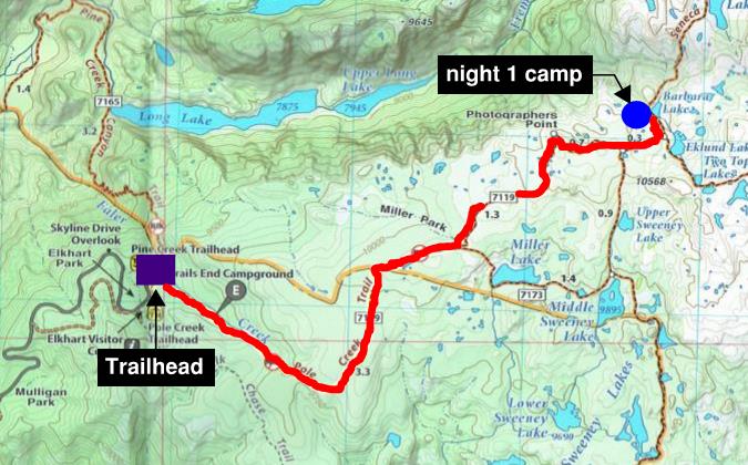
Our 7 day backpacking hike started at the trailhead at "Elkhart Park", which is reached by a 14 mile drive from Pinedale, WY on Freemont Lake Road & Skyline Drive. Because we were doing a loop hike, this would also be the ending point of the trip. The elevation at this trailhead is 9,380 feet, which is about 2,200 feet higher in elevation than the town of Pinedale. Our first day was a short segment, hiking 5.6 miles to Barbara Lake, while gaining 1,021 feet of elevation. This day's segment included the Pole Creek Trail and a small part of the Seneca Lake Trail. Most of this day's hike was in the timber with good views and more interesting scenery starting near Photographer's Point, about 4.8 miles from the trailhead. During the first 5 miles along this trail we were very surprised to have some cell service, albeit very weak service. So we were able to periodically check the score of the Texas-Alabama football game. The weather was perfect, sunny with not even a trace of a cloud. We encountered lots of other hikers, many with dogs, either day hiking to Photograher's Point or continuing on to overnight stays in the Titcomb Basin. Good, well used, but small sized camping spots were found at Eklund Lake and Barbara Lake. We camped the night at Barbara Lake.


Our second day trail segment was 6 miles from Barbara Lake to Island Lake, gaining 1,123 feet of elevation. This day's segment included portions of the Seneca Lake Trail and Indian Basin Trail. As in the previous day, we encountered quite a few other groups on the trail, heading back from or towards the Titcomb and Indian Basins. The weather was perfect. We stopped for lunch on the shore of Seneca Lake. Plenty of spots can be found to camp on the southwest, southeast and northeast sides of Island Lake. We set up camp in a decent sized open spot on the southeast end of the lake.


Day 3 was our 'layover' day when we explored the Titcomb Basin and Titcomb Lakes without packs - spending a second night at Island Lake. Day 3 was the last of the warm cloudless days. After reaching the Titcomb Basin, the hike was fairly flat to the end of the Titcomb Lakes. The roundtrip day hike in the Titcomb Basin was about 6 to 7 miles in length on portions of the Indian Pass and Titcomb Basin Trails.


Our fourth day trail segment was 8.2 miles from Island Lake to Elbow Lake, gaining 1,353 feet of elevation. This day's segment included portions of the Indian Basin Trail and Continental Divide Trail. This was the day that the weather started to change from warm and sunny with no clouds to cooler, cloudy and occasional rain. It was also the beginning of true solitude. Unlike the previous three days, when we were encountering countless other groups heading to or back from the Titcomb Basin, when we made the turn onto the Continental Divide Trail on day four to complete the rest of the loop, the sight of another hiker became rare. The scenery on this segment of the Continental Divide Trail was tremendous with towering craggy granite peaks while passing Lower, Middle and Upper Jean Lakes on our way to the night's camp at Elbow Lake. It was on this day that we reached the highest point on the entire loop, an elevation just above 11,000 feet near Elbow Lake. We were hit by some waves of cold rain and wind heading down into Elbow Lake and busted out the rain gear for the first time. We set up camp that afternoon in a field of granite and tundra near the shore of Elbow Lake, rested up in our tents for a while, before we all crawled out to enjoy the "Hindi Feast" that I cooked for dinner that evening.


Our day five trail segment was about 8 miles in length from Elbow Lake to Upper Neil Lake, while loosing about 1,000 feet of elevation. This day's segment included portions of the Continental Divide Trail and Summit Lake Trail. We woke at our Elbow Lake camp to find that were were enveloped in the clouds. This was the wettest weather day of the trip, with the entire day spent hiking in rain jackets and pants. There were periods of light to moderate rain for most of the day, until we were close to our Upper Neil Lake, where we set up camp. As we were getting close to Upper Neil Lake, the sky turned blue again and the rain quit. Summit Lake and Green River Pass were a highlight of the day.


Our final day of hiking this backcountry loop was a short 2.1 mile walk back to the parking lot at Elkhart Park, but the elevation gain was 1,453 feet, climbing out of the Pine Creek valley on the Long Lake Trail. It had started raining during the night and it remained a steady and torrential downpour during the entire hike back on this final segment. If there were good views to be seen on the trail, we couldn't see them on this day. We reached the parking lot and the car we had left there seven days prior before lunch time.


