

Trip Summary:


This was my fourth trek to Glacier National Park, but first since 2009. The place is easily one of the most popular places for backpackers to enjoy their hobby. In April I submitted my backcountry application knowing full well that I was unlikely to get exactly the route itinerary I wanted. Last year (2011) I made the mistake of requesting an itinerary with too large a group and not being flexible on trip dates I would accept. Without a decent itinerary at Glacier in 2011, things ended up working out great anyway when I took a group to the Canadian Rockies in British Colombia instead. This year’s trip had quite a different last minute challenge. I had received an itinerary from the park that, while not my first choice of routes, was in an area of the park I wanted to backpack. The issue became rounding out a group that could go. Up until a few months before the trip I had my solid group of four ready to go. But, when two of the four had to drop out at the last minute, I was scrambling to find others who could go along without a lot of advance notice. None of the people in my list of contacts could commit to the trip, so I turned to Matt and suggested that he reach out to his fellow members of the C.U. – Boulder hiking club. Matt received two responses from members of the club wanting to join us, Linda & Conor.
Linda was in Boulder for an internship, far from her native Holland, while Conor was a senior at C.U. from Grand Junction who Matt had backpacked with in the past. So at 32, I would be the old man in this group of engineering students. The plan was for Matt and I to fly from Austin to Great Falls, MT. We would meet up with Linda during our layover in Denver and all be on the flight together to Great Falls, where we would meet up with Conor. Conor was finishing up a summer internship at the Montana highway department in Helena and would pick up Linda, Matt & I in Great Falls and we’d head to Glacier for our week at the park. As I should by now be able to predict, issues caused by the airlines changed those plans. Instead of getting into Great Falls, Matt & I would end up meeting up with Conor & Linda at the front country campground a day later than anticipated by flying into Kalispell instead, then taking a series of shuttles to East Glacier after an overnight at the walk-up site at the campground on the west side of the park. Good times. Matt, Conor, Linda and I spent two days & two nights in the front country prior to the backpack in the park’s backcountry. During those two days the four of us did day hikes to Iceberg Lake and to Granite Park via the Garden Wall (Highline trail). The section of the highline trail we day hiked was great and reinforced my desire to one day hike the entire length of the highline as part of an extended backpack that includes the North Fork area of the park (Lake Francis, Hole in the Wall, Boulder Pass, etc.)
Our backpacking route (see map & distances below), extended over five days. We had the good fortune of experiencing the best weather I’ve encountered at Glacier – never once having to bust out the tarp to cook under or put on any rain jackets. The route was one of the least strenuous out all the backpacking routes I’ve done. Before we headed out into the backcountry Conor & I spent a long, very early morning at the St. Mary Ranger Station attempting to modify our permit under the “24 hr. walk-up” rules. One thing I did learn from that experience is that if you want to get a walk-up permit at Glacier, or modify an existing permit through the walk-up process, be prepared to book about 3 to 4 days worth of ‘route’ that you have no interest in doing in parts of the park backpackers find least appealing in front of the route that you are really interesting in doing. Despite more “down time” than I’m used to on backpacking trips, we did find ways to fill that time, including swims in Morning Star & Medicine Grizzly Lakes, some friendly card games, and a few rounds of vodka & whiskey. After our time in the backcountry, we left Glacier and Conor dropped Matt and I off in Great Falls, where we caught our flight back to Austin.
PICTURED BELOW: Iceberg Lake

PICTURED BELOW: If current climate change trends continue the habitat of this pale red-haired creature could soon be lost forever (Conor at Iceberg Lake)

PICTURED BELOW: A tarn below Iceberg Lake

PICTURED BELOW: Mount Oberlin from the "Garden Wall" near Logan Pass

PICTURED BELOW: Mount Oberlin, Clements Mt. & Mount Cannon

PICTURED BELOW: Granite Park Chalet

PICTURED BELOW: Grinnell Glacier & Upper Grinnell Lake

PICTURED BELOW: Grinnell Glacier & Conor at the brink

PICTURED BELOW: L to R: Matt, Linda & Conor enjoying the larger portion of the dinner that I didn't drop on the ground

- Backpacking Route on Glacier Park Map (38 miles) -

PICTURED BELOW: Sinopah Mountain from Two Medicine Lake

PICTURED BELOW: Linda at Two Medicine Lake

PICTURED BELOW: Oldman Lake, where we camped the first night.

PICTURED BELOW: Oldman Lake & Pitamakan Pass

PICTURED BELOW: Oldman Lake & Flinsch Peak

PICTURED BELOW: Nyack Creek Valley from Pitamakin Overlook

PICTURED BELOW: Mount Pinchot & Mount Stimson

PICTURED BELOW: Conor at Pitamakin Overlook

PICTURED BELOW: 180 degree look from Pitamakin Overlook

PICTURED BELOW: Mount Stimson & Tinkham Mountain

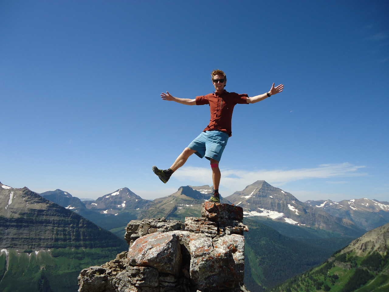
PICTURED BELOW: Conor demonstrates some balancing skills at Pitamakin Overlook
PICTURED BELOW: Conor at Pitamakin Overlook

PICTURED BELOW: What a backdrop for Linda to strike a pose

PICTURED BELOW: Lake below Pitamakin Pass

PICTURED BELOW: Lake below Pitamakin Pass

PICTURED BELOW: Lake below Pitamakin Pass

PICTURED BELOW: Lake below Pitamakin Pass

PICTURED BELOW: Morning Star Lake

PICTURED BELOW: Shore of Morning Star Lake

PICTURED BELOW: Waterfall & Medicine Grizzly Lake

PICTURED BELOW: Waterfall & Medicine Grizzly Lake

PICTURED BELOW: A great smile!

PICTURED BELOW: Hey Bartender....I'd like some warm vodka mixed with some lemon flavored Gatorade served in a dirty metal cup...... and stirred with your dirty finger. In the backcountry there's no such thing as a bad drink.

PICTURED BELOW: Good thing we weren't playing for money (Linda & Conor)

PICTURED BELOW: L to R: Matt, me & Linda

PICTURED BELOW: Razoredge Mountain & Medicine Grizzly Lake

PICTURED BELOW: Waterfall & Medicine Grizzly Lake

PICTURED BELOW: Conor (at right) on the way to Triple Divide Pass

PICTURED BELOW: Norris Mountain from Triple Divide Pass

PICTURED BELOW: Hudson Bay Creek Valley from Triple Divide Pass

PICTURED BELOW: Head of the Hudson Bay Creek Valley

PICTURED BELOW: On the way down from Triple Divide Pass

PICTURED BELOW: Conor takes a plunge into the cool waters of Red Eagle Creek

PICTURED BELOW: Morning at Red Eagle Lake camp

PICTURED BELOW: Morning at Red Eagle Lake camp

PICTURED BELOW: Morning at Red Eagle Lake camp
